
Would you book a room before checking whether the block outside is safe?
Most people glance at photos, compare price, and hit book; that’s how trips go wrong.
Five minutes of checking now saves a week of regret.
This guide gives six fast research steps: official crime maps, recent police logs, independent crime sites, satellite and Street View scans, local news searches, and local contacts, so you can spot red flags and pick a listing that protects your travel plans.
Do these checks before you enter payment info.
How to Quickly Check if a Neighborhood Is Safe Before Booking

Five minutes of checking now saves a week of regret later. Most people look at photos, glance at the price, and hit book. That’s where things go wrong.
The safest neighborhoods don’t advertise it in the listing title. The sketchy ones definitely won’t warn you.
You can inspect any neighborhood from your laptop using the same data local police departments use. Crime patterns, street conditions, all the red flags. You just need to know where to look.
Here’s the order that works:
1. Find the official crime map from the city or county police. Look within a half-mile of the property address. Set the date range to 12 months. Compare violent crime (assault, robbery, homicide) against property crime (theft, vandalism). If violent incidents cluster near your address, that’s a problem.
2. Pull up police blotters or incident logs for the past 30 to 90 days. Lots of departments post weekly or monthly summaries by area. Recent patterns matter more than year-old stats.
3. Cross-check with independent crime sites like SpotCrime, CrimeGrade, or NeighborhoodScout. Use two sources minimum. If both show a hotspot right where you’re booking, believe it.
4. Switch to satellite view. Scan the blocks around the property. Are buildings packed together or spread out? What’s nearby? Parks, shops, warehouses?
5. Drop into Google Street View and walk the route. Start from the nearest transit stop or parking area and move toward the entrance. Check for street lighting, active businesses, sidewalk quality, people around. If there’s nighttime imagery, compare day and night.
6. Search “[neighborhood name] crime” or “[neighborhood name] safety” in local news. Look at the past six months. One incident is random. Multiple mentions mean something’s going on.
Do all six before entering payment info. If two or more checks raise flags, pick a different listing. Most platforms let you filter by neighborhood anyway. Move to a safer zone in the same city and repeat.
Interpreting Guest Reviews for Hidden Safety Clues

Reviews rarely say “unsafe neighborhood” outright. But the signals show up anyway.
People write “sketchy block,” “sirens all night,” “didn’t feel safe after dark,” “lots of people hanging around outside.” Those phrases mean more than star ratings.
Look for patterns across platforms and timeframes. One comment about noise or loitering could be bad luck. Three separate mentions over six months? That’s consistent.
Stick to reviews from the past 12 months. Neighborhoods change. A place that felt fine two years back might’ve shifted.
Don’t just check the booking platform. Compare with Google reviews, TripAdvisor, local city forums. Hosts can bury or dispute negative feedback on their main platform, but guests often post the unfiltered version somewhere else.
Watch for these:
- “Wouldn’t walk here at night”
- “Heard shouting outside”
- “Saw police cars often”
- “Extra locks on doors and windows”
- “Felt nervous coming back late”
Three or more of those across different reviewers? Treat it seriously. Go back to crime data and Street View before you commit.
Using Local Crime Databases and Official Reports

City police departments publish crime data for public access. Updated weekly or monthly, broken down by type, date, location. You’re looking at the same numbers locals use.
Start with the city’s crime mapping portal. Search “[city name] crime map” or “[city name] police data.” Most bigger cities in the US, Canada, UK, and Australia have these. Enter the property address or cross streets, set the range to 12 months. Compare violent incidents (assault, robbery, shooting, homicide) with property crimes (burglary, theft, vandalism). Lots of property crime but low violence is different from regular assaults.
| Source Type | Information Provided |
|---|---|
| City crime portal | Interactive maps, incident counts by category, date filters, heatmaps |
| Police blotter | Weekly or daily incident summaries, narrative descriptions, arrest logs |
| Open-data dashboard | Downloadable datasets, trend charts, comparison by district or precinct |
| Neighborhood council updates | Community safety meetings, local concerns, recent changes in policing or lighting |
If the city doesn’t post crime data online, call the non-emergency police line. Ask for recent incident summaries. Smaller towns and rural areas usually provide this by phone or email within a day or two.
Understanding Daytime vs. Nighttime Conditions
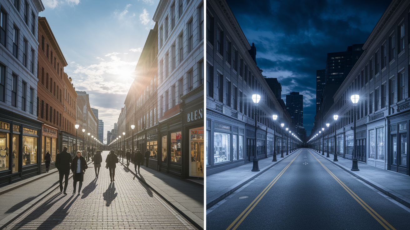
A street that’s busy and safe at 2 pm can turn quiet and isolated by 10 pm. Lighting drops. Foot traffic disappears. If you’re arriving late or eating dinner out, you need to check nighttime conditions separately.
Use Google Street View’s date and time filters when they’re available. Some cities have imagery from different times of day. If nighttime shots aren’t there, look for clues in the daytime view. Are streetlights installed and in decent shape? Are there restaurants, cafes, shops that stay open late? Check business hours on Google Maps. A block full of offices empties out after 5.
Local forums and recent reviews mention nighttime activity. Search “after dark,” “late night,” or “evening walk” in reviews and Reddit threads. If multiple people flag nighttime issues, plan your arrival during daylight or confirm the route from transit stays well-lit and active after 9 pm.
Identifying Physical and Environmental Red Flags
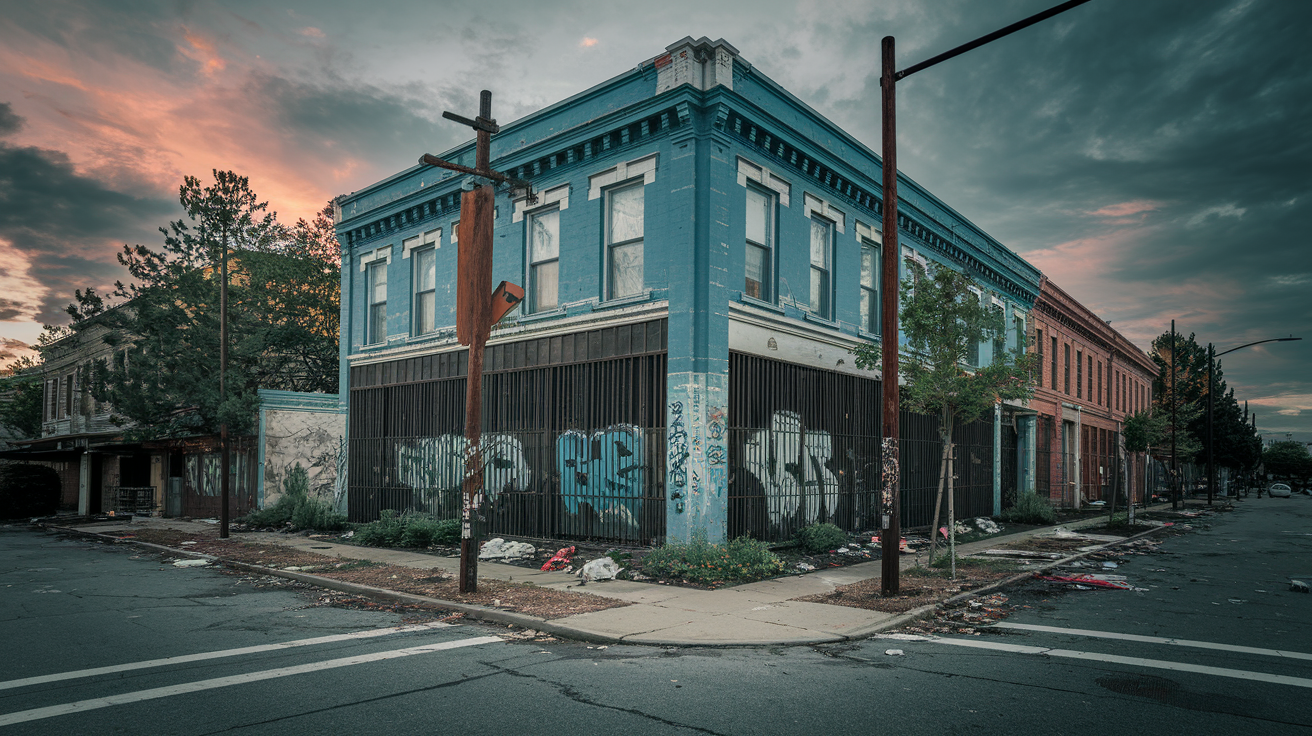
Visible neglect signals higher risk. Broken streetlights, boarded windows, overgrown lots, heavy bars on ground-floor windows, peeling paint across multiple buildings. These don’t guarantee crime, but they correlate.
Scan Street View and satellite imagery for these:
- Broken or missing streetlights on the route to the property
- Abandoned buildings or vacant storefronts on the same block
- Excessive graffiti, especially fresh and unrepaired
- Heavy security bars on most windows and doors
- Trash piles, overgrown weeds, general disrepair across properties
- Long stretches of blank walls, empty lots, or industrial zones with no pedestrians
- Lack of visible people or parked cars during daytime imagery
Four or more of these within two blocks? Move to a different neighborhood. One or two might just mean the area’s older or industrial. Clusters of neglect usually mean weaker services and slower response times.
Evaluating Proximity to Emergency Services and Key Infrastructure

Distance to hospitals, police stations, and transit hubs affects response time and general safety. Properties within half a mile of a police or fire station see faster help. Being close to major transit stops and commercial streets usually brings more foot traffic and lighting, which discourages crime.
Measure walking distance from the property to the nearest police station and hospital using Google Maps. Set it to walking mode and check the time. Under 15 minutes (about half a mile) is good. Between 15 and 20 is fine for most urban stays. Over 20 means you’re farther from help and probably in a quieter zone. If the property sits more than a mile from emergency services and crime data shows recent incidents nearby, weigh whether the price justifies the isolation.
Transit proximity cuts both ways. Being within 10 minutes of a subway or bus hub improves convenience and usually brings activity, which can feel safer. But some stops attract loitering or late-night disturbances. Check crime maps around the nearest station and read recent reviews mentioning transit safety.
Contacting Locals and Tourism Boards for Real‑Time Insights

Official crime data and reviews give you history. Locals give you now.
Neighborhoods shift. A block that was fine six months ago might’ve seen a spike in break-ins or a new nightlife cluster that changed things. Tourism boards, neighborhood associations, active community members fill in those gaps.
Start with the city or regional tourism office. Most answer emails within two or three business days. Ask directly: “I’m considering staying near [cross streets or landmark]. Any recent safety concerns or changes I should know about?” Keep it short and specific. Tourism boards want visitors to feel safe and they’ll usually be honest.
For faster input, post in the city’s subreddit (r/cityname) or search recent threads. Use keywords like “safe,” “neighborhood,” and the area name. Check posts from the past three months. If multiple locals flag the same thing, take it seriously. You can also join local Facebook groups or browse Nextdoor (if the city allows guest access) to see what residents are talking about.
Police non-emergency lines are another option. Call during business hours and ask if there’ve been recent incident trends or safety advisories for the neighborhood. Desk staff usually know the high-activity zones and can confirm whether your area’s seen changes.
Final Words
Start by running quick checks: crime maps, recent police reports, heatmaps, satellite view, and Google Street View for lighting and upkeep.
Then read guest reviews for coded warnings, note day vs night differences, watch for environmental red flags, and check proximity to emergency services.
This stepwise approach shows how to pick safe neighborhoods when booking accommodation by turning data and local insight into a clear yes or no. Do the six steps, trust patterns over single complaints, and you’ll pick a safer, calmer spot.
FAQ
Q: How to determine when making a hotel reservation that it is in a safe neighborhood?
A: To determine if a hotel reservation is in a safe neighborhood, check recent crime maps and police reports, scan satellite and Street View for lighting and upkeep, read guest reviews for nighttime warnings, and note proximity to police or hospitals.
Q: What is your most clever hotel room hack?
A: My most clever hotel room hack is using a portable door stop to jam the door from opening, giving instant, quiet extra security even when the deadbolt alone feels uncertain.
Q: What are the golden rules of a 5 star hotel?
A: The golden rules of a 5 star hotel are expect polished service, confirm what’s included, secure valuables in the safe, be courteous to staff, use the concierge, and tip for thoughtful service.
Q: Why put a washcloth in a hotel lock?
A: Putting a washcloth in a hotel lock is a quick privacy hack: stuffing cloth into the door gap or latch can make the door harder to force open and add a visible barrier when you’re inside.