
Want to spend less time commuting and more time doing things?
Choosing a hotel by transit beats picking one for looks.
Long walks, hidden transfers, and slow lines add stress and waste hours.
This post shows exactly how to pick a hotel based on transit access: how far to walk, what door to destination travel time to accept, how many transfers are reasonable, and which apps and tools to use.
You get a simple six-step checklist to test each property and basic safety checks for late nights.
Book smarter, save time.
Key Criteria for Choosing a Hotel With Reliable Public Transit Access

Four things make or break a transit-accessible hotel: how far you walk to the nearest stop, total door-to-destination time, how many transfers you’re stuck with, and how often trains or buses actually show up. Walking distance should sit between 400 and 800 meters, about 5 to 10 minutes on foot. Travel time from your hotel door to where you’re going should stay under 30 minutes when you can manage it. Try for routes with zero or one transfer. Each transfer tacks on 5 to 15 minutes plus whatever you spend waiting. Service frequency matters more than most people think. Lines running every 10 to 15 minutes give you real flexibility, while 30-minute gaps turn a “15-minute trip” into a 30 to 45 minute ordeal once you’re standing around waiting.
Use Google Maps to check transit access before you book. Open your main destination, turn on the transit layer to see lines and stations, then search for “hotel” to pull up bed icons and a list of nearby properties. Run transit routing from each hotel to your top two or three destinations at the times you’ll actually be traveling. Weekday morning, evening rush, and weekend if that’s relevant. The routing tool shows total travel time, transfers, and walking segments. Check which lines serve each stop and note how often they run during your stay.
Make sure to verify night and weekend operations, and confirm the walking route between hotel and station feels safe. Transit maps don’t show lighting, sidewalks, or steep hills. Use street view tools to check the path, and read reviews for mentions of unsafe walks or poorly lit stations. If you’re arriving late or leaving before dawn, confirm service runs at those hours. Many systems cut frequency or shut down overnight.
Six-step method for choosing a transit-accessible hotel:
- Identify your main destinations (conference center, museum district, family home, airport).
- Turn on the transit layer in Google Maps and locate stations near each hotel.
- Measure walking distance from hotel entrance to nearest frequent stop (aim for 400 to 800 meters).
- Check door-to-destination travel time using transit routing at planned travel times (aim for 30 minutes or less).
- Check peak and off-peak frequency for the lines serving that stop (aim for every 10 to 15 minutes).
- Count required transfers for your most common trips (aim for 0 to 1).
Understanding Hotel Location Choices Through Transit-Oriented Criteria

Distance on a map and real walking time aren’t the same thing. A hotel 600 meters from a station sounds close, but if that walk crosses a highway or climbs a steep hill with no sidewalk, it’s not practical with luggage. Use street view tools to trace the walking route and confirm it’s flat, well lit, and has continuous sidewalks. A property 700 meters away on a direct, level path beats one 500 meters away that requires stairs or a detour through an unlit alley. Walking time matters more than map distance. Before you book, walk the route on street view.
Choose neighborhoods based on your most frequent destinations, not on being “central.” If you’re attending a conference in a business district, a hotel near a direct line to that district saves time every day, even if the hotel itself sits outside the tourist core. If you’re visiting family in the suburbs, staying near a commuter rail line beats staying downtown and transferring twice. Trace your daily routine on a transit map. If most trips require multiple transfers or long walks, the hotel’s location isn’t working for you.
Five factors that define a transit-oriented neighborhood:
- Safe, well-lit streets between hotel and station with clear sightlines at night
- Sidewalks in good repair, wide enough for rolling luggage
- Station entrance visible from street level, not hidden in underground passages or behind buildings
- Frequent service lines (every 10 to 20 minutes) during your travel hours
- Step-free access or elevators at station and hotel entrance
Practical Tools and Apps for Verifying Hotel Transit Access

Google Maps transit routing is the fastest way to check hotel access. Open the app, search for your main destination, tap Directions, and choose the transit icon. Enter the hotel address as your starting point and set the departure time to match your planned travel hours. The app displays total travel time, walking segments, wait times, and transfers. Tap each line name to see its route and frequency. Use the Measure Distance tool to confirm the hotel-to-station walk in meters. Check multiple times of day. Rush hour, midday, and evening, because headways and route options often change.
Transit apps like Citymapper, Transit App, and Moovit show real-time arrivals, delays, and service alerts. Download the app for your destination city and save the hotel address. These apps often display headways more clearly than Google Maps and include crowd-sourced accessibility data and alternate routes during disruptions. Use them to check weekend and late-night service patterns before you finalize your booking. If the app shows frequent gaps or long waits during times you’ll travel, that’s a sign to keep looking.
Local transit agency websites publish official timetables, service calendars, and system maps. Search “[city name] transit agency” and look for a trip planner or schedule page. Some agencies publish rail-to-hotel directories or downtown transit maps showing hotels within walking distance of major stations. These resources work especially well for rail-focused trips. A rail-to-rooms directory compiles properties near Amtrak or regional rail stations, sorted by walking distance.
| Tool | What It Verifies | When To Use It |
|---|---|---|
| Google Maps transit routing | Walking distance, total travel time, transfers, line names | First check (simulates your actual trips at planned times) |
| Citymapper / Transit App / Moovit | Real-time arrivals, frequency, service alerts, accessibility notes | Second check (confirms service reliability and real-world conditions) |
| Local transit agency website | Official timetables, first/last run times, fare structure, weekend schedules | Final check (verifies service span and fills gaps in third-party apps) |
Evaluating Transit Quality: Frequency, Reliability, and Transfers
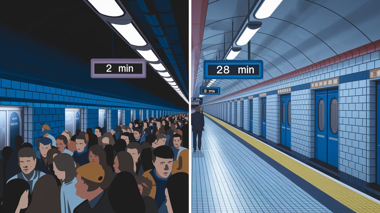
Frequent service means trains or buses arrive every 10 to 15 minutes. That level of frequency lets you leave when you’re ready without checking a schedule. Infrequent service, every 30 minutes or longer, forces you to plan departures around the timetable and turns missed connections into long waits. A line that runs every 30 minutes has an average wait time of 15 minutes, so a trip Google Maps shows as 15 minutes typically takes 30 minutes, and can stretch to 45 minutes if you just miss a departure. Always check headways during your travel hours, not just whether a line exists.
Each transfer adds 5 to 15 minutes to your trip, plus the risk that a delay on one line makes you miss the next. A route requiring two transfers for a routine trip (hotel to conference center every morning, for example) will cost you 20 to 40 extra minutes per day compared to a direct line. Transfers also multiply the impact of service disruptions. If one line is delayed, your entire trip stalls. Aim for zero transfers to your most common destinations, and accept one transfer only if both lines run frequently and the transfer station is well designed with short walking distances between platforms.
Reliability depends on headway consistency and service span. A line that runs every 12 minutes during weekday peaks but drops to every 40 minutes on weekends isn’t reliable for a leisure trip. Check the timetable for gaps during the times you’ll actually travel. Some systems shut down overnight or reduce service sharply after 8 pm. Verify first and last departure times for the lines serving your hotel, especially if you have early flights or late dinners planned. A hotel that’s perfectly connected at noon but isolated at 11 pm isn’t transit-accessible for real travel schedules.
Safety, Accessibility, and Walkability Factors Around Hotel Transit Stops

Look for well-lit sidewalks with good sightlines between the hotel entrance and station. Streets should feel open, not isolated, especially if you’ll be walking at night. Station entrances should be visible from the street, not hidden in underground passages or behind parking structures. Avoid routes that require crossing busy intersections without signals, or walking through empty lots or poorly maintained areas. If street view imagery shows cracked sidewalks, missing lighting, or long stretches with no shops or foot traffic, that’s a red flag. Safety isn’t just about crime. It’s about feeling comfortable enough to use transit regularly.
Accessibility matters for luggage and mobility. A hotel 500 meters from a station sounds walkable, but if that route includes stairs, steep hills, or narrow sidewalks, it’s not practical when you’re carrying bags or traveling with mobility aids. Check whether the station has elevators or ramps, and confirm the hotel entrance is step-free. Even a single flight of stairs at either end can make the trip frustrating. If you’ll be hauling a suitcase daily, test the route mentally. Flat, smooth sidewalks and step-free access at both ends should be non-negotiable.
Six walk-quality checks:
- Lighting: streetlights, station lighting, and storefront illumination at night
- Sidewalks: continuous, wide enough for two people with bags, smooth surface
- Slopes: minimal grade, no long uphill stretches, no stairs between hotel and station
- Crossings: signalized intersections, crosswalks, short wait times
- Elevators: present at both hotel and station if either is multi-level
- Station visibility: entrance clearly marked and visible from the street
Red Flags When Selecting a Hotel Based on Transit Access

Hotels that claim to be “close to transit” without naming the specific station or providing walking time are using marketing-close, not objective-close. If the listing says “near public transport” but doesn’t tell you which line or how many meters, assume it’s farther than you want. Look for listings that state “350 meters to [Station Name], 4-minute walk” with the line names included. Vague claims are often a sign that the walk is long, complicated, or crosses unsafe areas.
Operational red flags include service frequency below 20 minutes during the times you’ll travel, limited weekend or night service, and systems that require multiple transfers for routine trips. A hotel served by a single bus line running every 40 minutes isn’t transit-accessible in any practical sense. You’re tied to a timetable and every missed bus costs you 40 minutes. Check the service span carefully. If the last departure is at 9 pm and you’re planning evening activities, the hotel is effectively disconnected after dinner.
Five red flags to avoid:
- Station proximity undefined (listings that say “near transit” without naming stops or giving distances).
- Infrequent headways (service running every 30 minutes or longer during peak times).
- Unsafe or inconvenient walks (routes requiring highway crossings, poorly lit paths, or steep climbs).
- Multiple required transfers (needing two or more connections to reach your main destinations).
- Limited weekend or night service (systems that shut down or drastically reduce frequency outside weekday peaks).
How to Compare Multiple Transit-Accessible Hotels

Start by measuring walking distance from each hotel entrance to the nearest frequent stop. Use the map’s measure tool to get meters, not just minutes, because walking speed varies with luggage and terrain. A 400-meter flat walk beats a 600-meter walk that includes stairs. Then simulate door-to-destination trips at the times you’ll actually travel (morning, evening, weekend if relevant) and record total travel time including walking, waiting, and in-vehicle time. A hotel that’s 100 meters farther from a station but on a direct frequent line often beats a closer hotel requiring transfers.
Compare peak and off-peak headways for the lines serving each property. A hotel on a line running every 10 minutes at rush hour but every 40 minutes on weekends isn’t a good choice for a leisure trip. Count required transfers for your top three destinations and note transfer station quality. Some transfers are quick platform-to-platform hops, others require long walks through crowded concourses. Factor in luggage access at every stage. If one hotel requires stairs to reach the platform and another has elevators, that difference matters more than a few minutes of travel time.
Check proximity to airport rail links if your trip starts or ends at the airport. A hotel 15 minutes from the airport on a direct rail line can save you taxi costs and stress on both ends of your trip. Compare total cost of transit passes plus hotel rate against properties that are slightly more expensive but closer to your destinations. Sometimes paying an extra $20 per night to cut 40 minutes off your daily commute is worth it. Price vs convenience is always a tradeoff. Calculate the time savings in hours over your entire stay.
| Hotel | Walk Distance (m) | Travel Time (min) | Transfers |
|---|---|---|---|
| Property A | 450 | 22 | 0 |
| Property B | 600 | 28 | 1 |
| Property C | 350 | 35 | 2 |
| Property D | 800 | 18 | 0 |
Questions to Ask a Hotel About Their Transit Access

Confirmation matters because hotel marketing copy often overstates transit access. Staff replies give you specific names, numbers, and routes you can verify independently. Ask before you book, not after you arrive. If a hotel can’t answer these questions or gives vague responses, that’s a signal they don’t understand transit access or the property genuinely isn’t well connected.
Seven questions to ask:
- What is the name of the nearest transit stop and the exact walking distance in meters and minutes?
- Which lines serve that stop, and what are their route numbers or names?
- What is the frequency (trains or buses per hour) during weekday peak, weekday off-peak, and weekend hours?
- What time do the first and last departures run on weekdays and weekends?
- What is the typical transit travel time from your property to [name your top two destinations], and how many transfers are required?
- Is the walking route from your entrance to the station step-free and suitable for rolling luggage?
- Do you provide printed transit maps or realtime schedule assistance at the front desk?
Using Reviews and Real-World Traveler Feedback to Validate Transit Access

Reviews often reveal the gap between a hotel’s marketing and the actual walk to the station. Search for keywords like “subway,” “metro,” “bus,” “walk,” “station,” and “transit” in guest reviews. If multiple travelers mention a “15-minute walk” when the hotel claims 5 minutes, trust the reviews. Look for comments about unsafe routes, poor lighting, or confusing station access. Repeated complaints about noise from trains or buses indicate the hotel is right on top of a line, which can be a problem for light sleepers even if transit access is excellent.
Photos in reviews and listings sometimes show the real story better than descriptions. Check whether the station entrance is visible in photos, or if you see highways, construction barriers, or empty lots between the hotel and the transit stop. User-uploaded images often capture the walk at street level, showing you whether sidewalks are wide and maintained or narrow and cracked. If official hotel photos never show the station or walking route, that’s usually a sign the walk isn’t as convenient as the text claims.
Start by treating distance, travel time, frequency, and transfers as non-negotiables—aim for 400–800 m, ≤30 minutes door-to-destination, 10–15 minute headways, and 0–1 transfers.
Confirm with Google Maps’ transit layer and a real-time app, check walking routes for lighting and steps, ask the hotel for station names and first/last runs, and scan recent reviews and photos for surprises.
Use the 6-step checklist and trust those objective checks. This is how to pick a hotel based on public transit access — clearer choices, less stress, better days on the road.
FAQ
Q: How does a transit hotel work?
A: A transit hotel works as a short-stay room inside or near an airport or station, booked by the hour or night for layovers, tight connections, or overnight waits, often with luggage storage.
Q: What is the difference between 1, 2, 3, 4, 5 star hotels?
A: The difference between 1–5 star hotels is level of service, room quality, and amenities: 1 basic budget, 2 simple comforts, 3 reliable mid-range with dining, 4 full-service, 5 luxury with concierge and spa.
Q: Do you need proof to book an accessible hotel room?
A: You need proof to book an accessible hotel room in some places, but most hotels accept a guest’s stated need; carry documentation or a mobility-aid photo if requested and confirm the policy before booking.
Q: What is BB, HB, and FB in hotels?
A: BB, HB, and FB in hotels are meal plans: BB is bed and breakfast, HB (half-board) includes breakfast plus one main meal, and FB (full-board) includes both main meals; all-inclusive adds drinks and extras.